想创作具有影棚级质感且情绪松弛的艺术大片,却苦于无法完美呈现 国际主义纪实风格城市韧性防涝报告设计 中复杂的细节与光影质感?
Nanobanana Pro 完美还原了画面的细腻纹理与高级氛围,助您精准定格具备顶尖商业杂志感的视觉瞬间。
复制这套免费提示词,一键复制进顶级模型,秒出大片。
Struggling to create International Style Documentary City Resilience Report Ppt with a high-end editorial style? Nanobanana Pro captures the textures and lighting details perfectly for a hyper-realistic masterpiece. Get FREE Prompt, enjoy one-click copy, and create instantly!
Prompt (English):
ADVERTISEMENT
Build a report-type PPT that juxtaposes large-scale documentary photography with clear information architecture, with the internationalist layout system as the main axis: use modular grids and baseline grids to lock column widths, margins, title and body rhythms; use Gestalt law of proximity and common areas to cluster content into scannable blocks; use editorial rhythm to create tension and relaxation between main visual pages, white-space information pages, and multi-column data pages. Borrow Josef Müller-Brockmann's asymmetric mathematical grid to govern alignment, Alexey Brodovitch's radical cropping, image scale, and white space to create narrative pauses, Massimo Vignelli's limited fonts and unified components to maintain consistency throughout the set, and Josef Albers' adjacent color field relationships to calibrate the recognition of chapter color tabs and information cards, with each method managing one domain without mechanical imitation. Establish replaceable color roles: main visual field accounts for 55%—70%, medium-dark values, medium-high saturation, and retaining natural light and dark levels; paper background accounts for 20%—35%, high brightness, low saturation; structural text accounts for 8%—15%, ensuring clear projection with extreme light-dark contrast; chapter coding and key prompts together account for 3%—8%, using multiple groups of equally-weighted high-purity colors to produce temperature and saturation jumps between adjacent modules. Future themes or brand colors are mapped item by item according to main visual, background, text, coding, and prompts, replaced once while maintaining area proportions, brightness sequences, chromaticity differences, adjacency relationships, and contrast intensity. Pages run on asymmetric multi-column grids: theme pages let high-angle top-down documentary photography become the main quality, placed within large rounded corner boundaries, forming three-stage reading with small logos, theme titles, and oversized time information; content pages combine column text, equal-height cards, and edge-aligned narrow chapter color tabs in wide outer margins, allowing a single title or photograph to break across columns; the bottom edge of the information card is gathered with a single-pointing folded corner, the first reading is the title or focal image, the second reading is the summary, and the third reading is the details. Photography uses real ambient light, subtle grains, and brightness compression from near to far, performing natural tone correction first, then cropping with rounded corner masks, retaining edge details and local highlights; information pages use textureless matte backgrounds, overlaying low-transparency outline numbers, single-line geometric icons, and thin color bars, synthesized in the order of background, image or card, structural lines, text, and coding. Adopt coordinated pairings of same-skeleton geometric sans-serifs: display characters are oversized, bold-narrow, tightly tracked, and can cross columns, partially turning into hollow outlines, forming character-image overlapping with photography; the body text uses regular weight and higher line spacing, and the caption text is smaller but with wider letter spacing. Chinese and English font sizes are aligned by optical blackness rather than nominal size, correcting optical margins for numbers, full-width punctuation, and rounded boundaries, and the body text avoids complex images. The overall presentation is credible, clear, pragmatic, open, organic, and action-oriented.

——————
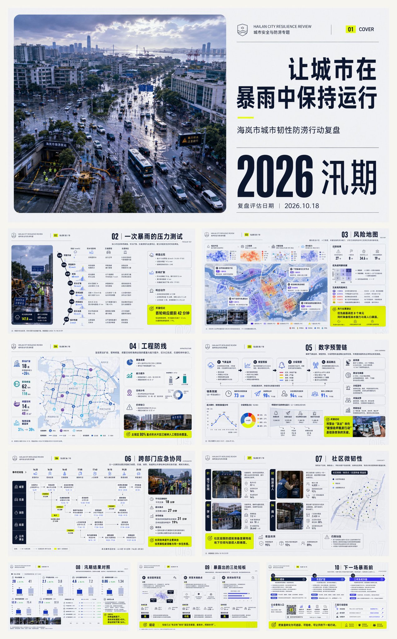
Theme: Review of Hailan City's Urban Resilience and Flood Prevention Actions
A total of 10 pages
Aspect ratio 16:9
Content logic:
01|Cover: Keeping the city running during heavy rain—lock the 2026 flood season review theme and assessment date with high-angle top-down documentary images of the urban area after the rain.
02|A heavy rain stress test: restore precipitation peaks, water accumulation diffusion, traffic disruption, and disposal response hour by hour, establishing a temporal causal chain of problem occurrences.
03|Risk Map: overlay low-lying areas, population density, critical facilities, and drainage capacity, identifying five types of high-risk units and their priority judgment basis.
04|Engineering Defense Line: present the coverage and capacity improvement of pump station expansion, pipeline network repair, storage space, and sponge facilities, distinguishing between completed, under construction, and gaps to be filled.
05|Digital Early Warning Chain: explain how meteorological monitoring, model forecasting, graded early warning, and grassroots reach are connected, and verify system effectiveness with lead time and arrival rate.
06|Cross-departmental Emergency Coordination: show task handovers, time consumption, and bottlenecks among urban management, transportation, fire protection, sub-districts, and public utilities through a real disposal process.
07|Community Micro-resilience: focus on four scenarios: underground spaces, elderly living alone, schools, and merchants, explaining the coverage effects of community plans, material points, and volunteer networks.
08|Flood Season Result Comparison: compare this year with historical rainfall of the same level, presenting the number of water accumulation points, water recession duration, suspension time, and loss changes, avoiding only reporting inputs.
09|Three Exposed Shortcomings: clarify old pipeline network blind spots, early warning terminal breakpoints, and insufficient nighttime coordination, providing evidence, impact scope, and rectification priorities respectively.
10|Before the Next Heavy Rain: form an action roadmap for 90-day repairs, annual expansion, and three-year system upgrades, implementing responsible departments, completion standards, and public inquiry portals.
Layout strategy: Use storm blue-purple as the main visual, cold grey-white background, and fluorescent yellow prompt colors to create a high-alert contrast, structural text is near-black; the cover lets a large rounded-corner aerial view on the left run through the top and bottom, with oversized time and short titles stacked on the right, inner pages use diagonal event trajectories, unequal narrow and wide double columns, partial cross-column risk maps, and full-page conclusion rotations, titles are right-aligned and preceded by numbers, time review is compact, risk explanation has white space, and the action list increases density again.
中文参考:
ADVERTISEMENT
构建以大尺度纪实摄影与清晰信息架构并置的报告型PPT,以国际主义版式体系为主轴:用模块网格与基线网格锁定列宽、边距、标题和正文节奏;用格式塔接近律与共同区域把内容聚为可扫读板块;用编辑节奏在主视觉页、留白信息页和分栏数据页之间形成张弛。借鉴约瑟夫·米勒-布罗克曼的非对称数学网格统领对齐,亚历克谢·布罗多维奇以激进裁切、影像尺度和留白制造叙事停顿,马西莫·维涅利用有限字体与统一组件维持整套一致,约瑟夫·阿尔伯斯以相邻色域关系校准章节色签与信息卡的辨识度,方法各管一域而不机械临摹。建立可替换色彩角色:主视觉场占55%—70%,中暗值、中高饱和并保留自然明暗层次;纸面背景占20%—35%,高明度、低饱和;结构文字占8%—15%,以极端明暗反差确保投影清晰;章节编码与关键提示共占3%—8%,用多组等权高纯度色在相邻模块间产生冷暖与饱和度跳变。未来主题或品牌色按主视觉、背景、文字、编码、提示逐项映射,一次替换并保持面积比例、明度序列、色度差、邻接关系与对比强度。页面以非对称多栏网格运行:主题页让高位俯视纪实摄影成为主要质量,置于大圆角边界内,以小型标识、主题标题和超大时间信息形成三段阅读;内容页在宽阔外边距中组合分栏文本、等高卡片与贴边窄幅章节色签,允许一处标题或摄影跨列破格;信息卡底缘以单一指向折角收束,第一读为标题或焦点影像,第二读为摘要,第三读为细节。摄影采用真实环境光、细微颗粒与由近及远的明度压缩,先做自然影调校正,再以圆角遮罩裁切,保留边缘细节和局部高光;信息页使用无纹理哑光底,叠加低透明度轮廓数字、单线几何图标与细色条,按背景、影像或卡片、结构线、文字、编码的顺序合成。采用同骨架几何无衬线的协调配对:展示字超大、粗窄、紧排并可跨列,局部转为空心描边,与摄影形成字像叠压;正文用常规字重和较高行距,说明文字更小但放宽字距。中英文字号按光学黑度而非名义尺寸对齐,校正数字、全角标点与圆角边界的光学边距,正文避开繁复影像。整体呈现可信、清朗、务实、开放、有机、行动导向。

——————
主题:海岚市城市韧性防涝行动复盘
一共10张
比例16:9
内容逻辑:
01|封面:让城市在暴雨中保持运行——以雨后城区高位俯视纪实影像锁定2026汛期复盘主题与评估日期。
02|一次暴雨的压力测试:按小时还原降雨峰值、积水扩散、交通受阻和处置响应,建立问题发生的时间因果链。
03|风险地图:叠加低洼片区、人口密度、关键设施和排水能力,识别五类高风险单元及其优先级判断依据。
04|工程防线:呈现泵站扩容、管网修复、调蓄空间和海绵设施的覆盖与能力提升,区分已完成、在建和待补缺口。
05|数字预警链:解释气象监测、模型预报、分级预警和基层触达如何衔接,并用提前量和到达率验证系统效能。
06|跨部门应急协同:以一次真实处置流程展示城管、交通、消防、街道和公共事业单位的任务交接、耗时与堵点。
07|社区微韧性:聚焦地下空间、独居老人、学校与商户四类场景,说明社区预案、物资点和志愿网络的覆盖效果。
08|汛期结果对照:将本年度与历史同等级降雨对比,呈现积水点数量、退水时长、停运时间和损失变化,避免只报投入。
09|暴露出的三处短板:明确老旧管网盲区、预警末端断点与夜间协同不足,分别给出证据、影响范围和整改优先级。
10|下一场暴雨前:形成90天修补、年度扩容和三年系统升级的行动路线,落实责任部门、完成标准与公众查询入口。
版式策略:以暴雨蓝紫为主视觉、冷灰白背景和荧光黄提示色制造高警觉反差,结构文字近黑;封面让左侧大圆角航拍贯穿上下,右侧堆叠超大时间与短标题,内页采用斜向事件轨迹、窄宽不等双栏、局部跨列风险图和满页结论轮换,标题右对齐并以编号先行,时间复盘紧凑、风险解释留白、行动清单再提升密度。